Our "mountain cam" link indicated that Jungfrau was sunny this morning, so we set off on our adventure from Interklaken (elevation 1,860 ft). We traveled from the West to the East Interlaken station and then took the train to Grindenwald (elevation 3,390). It was about a 30 min ride up the valley, some of which paralleled this glacier melt river coming out of the mountains.


We passed through the 'lower mountains' (?) before reaching the snow capped ones.
The colors were spectacular!

When we reached Grindenwald we transferred to the Eiger Express, a large gondola that holds approx 15 people. I learned that this was just barely opened two years ago. I knew when I was here 12 years ago we had ridden a train the whole way, so it was interesting to learn this access was brand new.

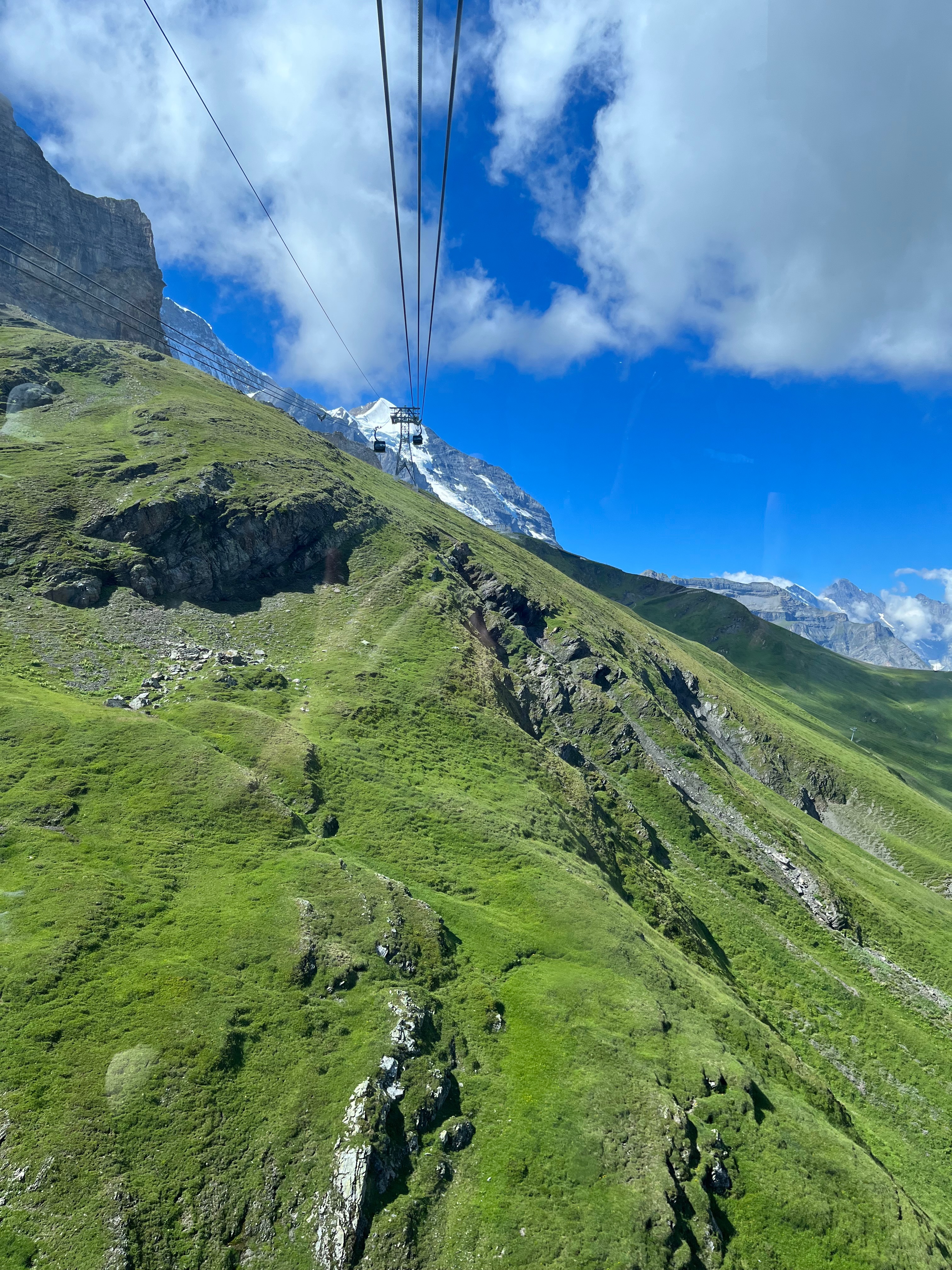
The gondola was very high above the ground and had an indescribable view of the Grindenwald valley as we climbed the mountatin.

View looking back down the cable line.

View looking at the top of the gondola.

Looking at the cog rail line running up from Grindenwald. There were parts that were covered over to protect the track from avalanches. I believe its open year round, but I'm not certain. Jungfrau is accessible all year, but there are gondolas, cog rail lines and funiculars that crisscross the region so I'm not sure what the winter access looks like.

The gondola put us out at Eigergletscher - Eiger glacier.
Elevation 7611 ft.

This was our first view from the Eiger glacier train station.

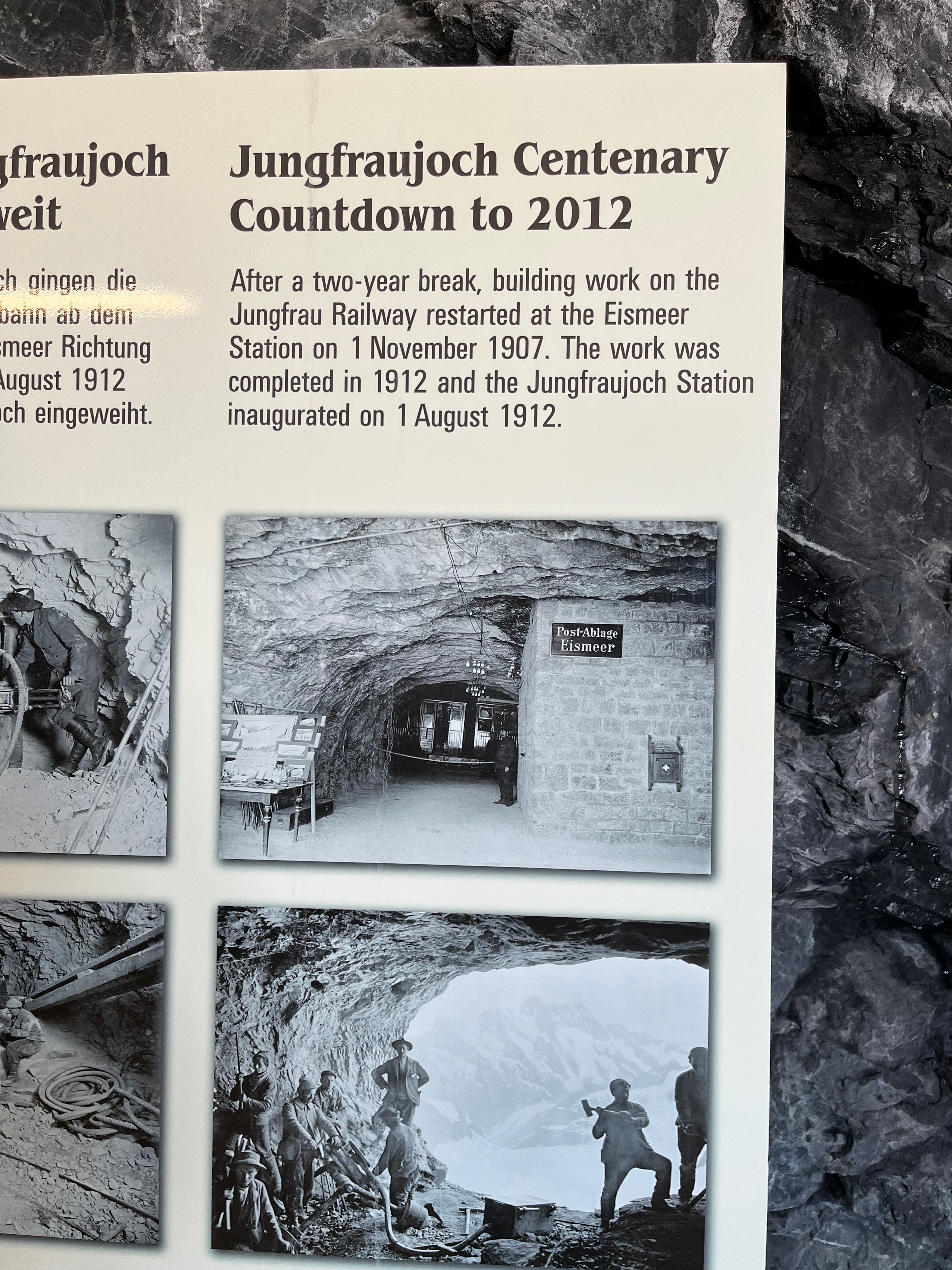
From the Eiger Glacier station to Jungfrau Joch, the train runs 9 km through the Eiger and Jungfrau mountains to come out on the saddle of Jungfrau. This construction was done in the early 1900s with the train opening in 1912. The workers blasted holes in the north face of the Eiger glacier to dump the rock out of the tunnels. These windows have been installed for people to see the glacier midway through the tunnel to the top.

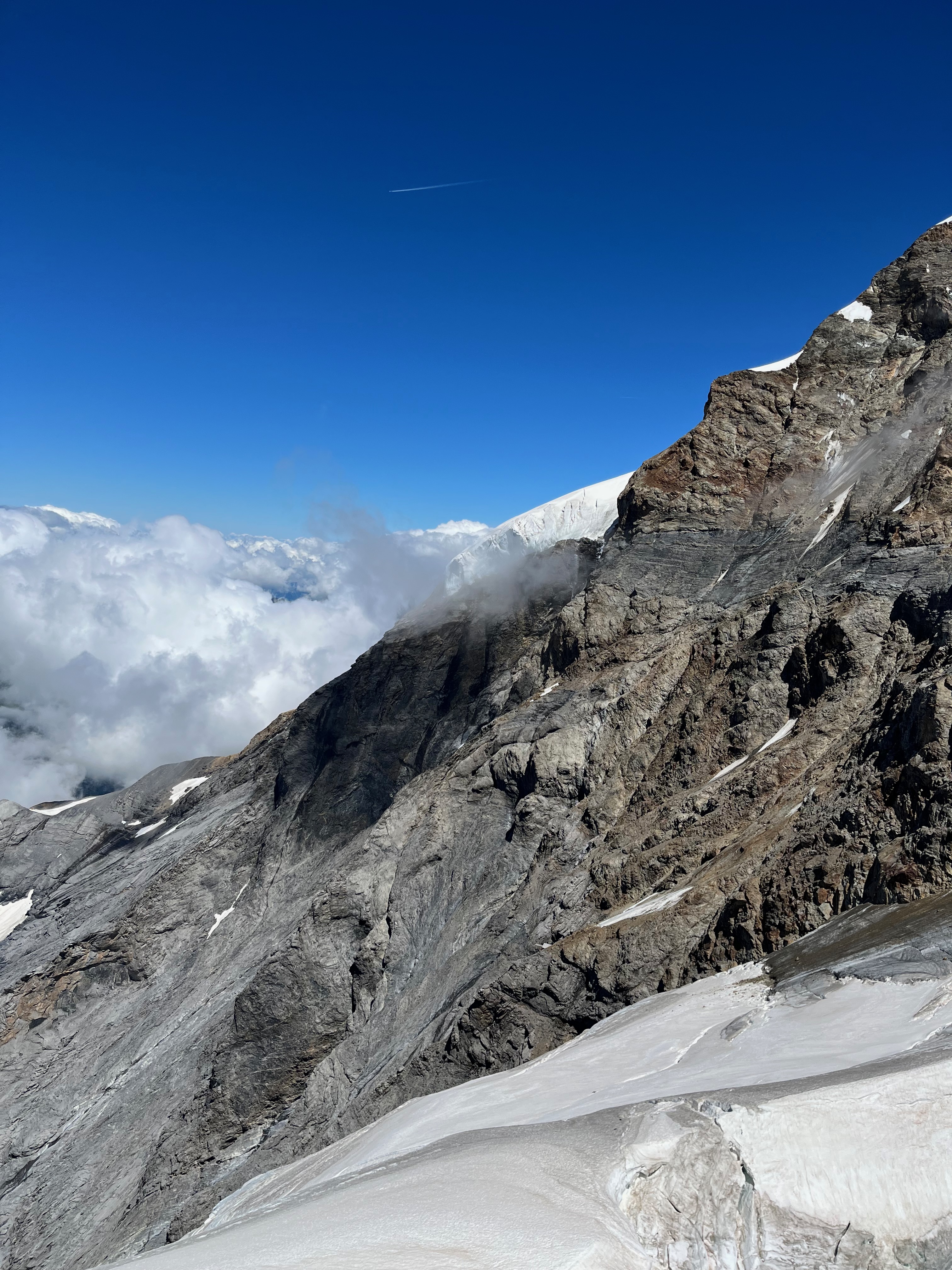
Eiger glacier from the mid-tunnel stop


The Jungfrau train.
(Definitely upgraded from when I was here with students 12 years ago).
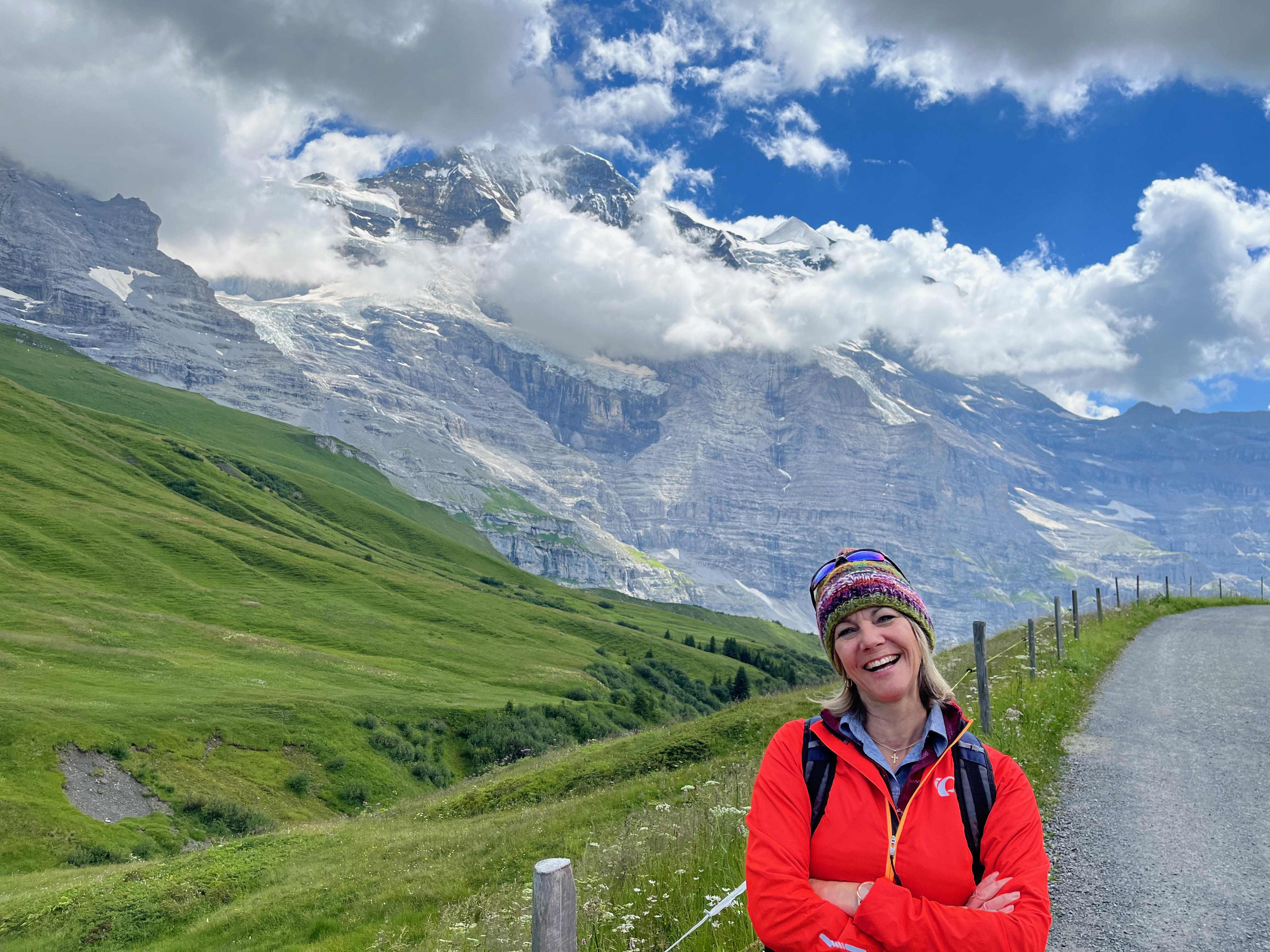
Elevation 11,333 feet. Gain of 10,000+ feet in just two hours. We were drinking lots of water, but still feeling a little light headed.


Jungfrau glacier - the longest in the alps

Jungfrau peak directly behind me.


The visitor center(s) are the two buildings in the face of the mountain on the right.
In the distance is the "sphinx" scientific observatory (and visitor deck). It opened in 1937 and has been upgraded several times. There was a fire in the 1970's that burned the visitor centers to the ground. Everyone managed to escape unhurt to the train tunnel. They had it open again for business in a very short time. Over 1 million visitors arrive each year.

From inside the visitor center you can walk through the "ice palace" which is literally carved into the Eiger Glacier. There are various ice sculptures in the caves (and it is cold!)


We saw a lot of pictures of 'stunts' at the Top of Europe - tennis matches, basketball games, even hot coal walking. This is from a pianist who played a brief concert. I can't image it was very good for the piano, but on warm days its around 30 F.


There is significant research that happens at the observatory. Rooms for multiple visiting scientists and multiple laboratories and lots of atmospheric sampling.


We stayed up top for about an hour and the clouds started to roll in more as we watched.

There's a glacier lake visible in this picture.
There is a trail to hike there, but its far longer than we wanted to take.

The observatory and observation deck. There were crows that lived up there an were fed daily by one of the workers. They recognized him and would come down and perch on his hand for a seed snack.


We decided the sunny side of the observation deck (out of the wind) was a great place for our picnic lunch.

Watching the clouds drift over the peaks was really mesmerizing.
We finally decided to head back down the mountain. We took the cog rail down from the top to Kleine Scheidegg station (not too far from the top of the Eigergletscher gondola).

This is looking down the mountain from the train.

This is looking up the track from Kleine Scheidegg. (Part of the track is covered to protect it from snow cover).

Train headed back up the mountain toward Eigergletcher station.

A paraglider above the glacier. It had to be very cold up there!

We picked up a hiking trail that ran from Kleine Scheidegg to Wengen along the rail tracks. This would take us down a different valley from the one we came up on the way to Grindenwald.


The wildflowers were amazing (and so were the peaks, obviously!)
The trails we've seen have all been well marked and in great condition. This one was graveled the whole way (which I was kind of not liking by the bottom because it was hard on the feet. Some pine needle covered dirt would have been wonderful at some point along the way).

These flowers reminded me of jelly fish for some reason, the balloon-like shape I guess. We found out later on our Flower walk that these are called Bladder Campions. They bloom through most of the summer.


We ran into several cows. One herd of about 10 all had on cow bells and they were making quite a ruckus as they grazed.

Looking down the valley toward Lauterbrunnen.

This small refrigerator unit was along side the path at one point. Electrically powered an all. It had several rounds of homemade (?) swiss chees in it with prices. Honors system - take some an leave money. Strangest 'vending machine' I've ever seen on a hiking trail!

Good signage. There were several options to get to Wengen. I'm glad we chose the shortest one in the end. My feet were beat by the bottom.


The Queen Anne's lace was so pretty!

We came across this sign midway toward Wengen. It shows a slalom race course from the top of a peak that intersects with the trail we were on where the trail turns toward the left midway down (Alpweg-Kernan S). The run continues all the way down the trail we were on to the town of Wengen. The skiers are moving at close to 100 km/hr on much of the track which is only about 10 feet wide throughout. Almost no space to slow your speed as you fly along the cliffs, take hairpin turns and zip past the trees. A terrifying run if you ask me.
Watch the full video of the ski race here.

Same slope as above but in the summer. [Taken from Murren] Our trail from Kleine Scheidegg followed the lower ski run after the big turn.


The highest peak on the left on this photo is Birg peak. One of the grassy glens below it is the town of Murren. Several days later we were on the other side of the valley and up in Murren, looking across at the spot where we are standing for this photo. We remarked when we say the town of Murren "who builds a village at the top of a cliff?"

The high point on the right side of the photo is the same peak but from a much closer perspective. [From Murren flower walk]

I think the peak in the distance is Laucherhorn (above Wengen). We could see A LOT of avalanche fences scattered across the top.

We finally got below timberline and hiked in the forest a bit. It was good because it was getting warm. We slowly peeled off our layers that we had had up top.


Train passing by on the trail.


Approaching Wengen (in the distance). Current elevation 4,950.

We saw several chalets that were decorated with large cow bells.
Not sure of the significance.

As we approached Wengen, the trail became paved and we just strolled right into the center of town.


A close up of the snow fences on Lauterhorn.

Wengen

Fondue dinner to reward ourselves.

Our view at dinner. We hiked that!

After dinner in Wengen, we took the train to Lauterbrunnen and then into Interlaken.
Spectacular cliffs and waterfalls - our planned hike for Tuesday!

This train had great viewing windows. I remember when I was here last, we were hanging out the open windows to take pictures and the train was MUCH older.

Lauterbrunnen

No comments:
Post a Comment