We did a slow start today, recovering a bit from our hiking yesterday. My big toe and baby toe had pretty big blisters that will need a day to heal up. We decided we would explore Harder Kulm, an overlook point above Interlaken on the north side of the town (near where all the paragliders have been launching). There is a funicular that goes up the slope and puts you out on top.
This view shows you the second half of the track after it turns the corner with the station at the top.
We've had some fun trying to figure out the names of various modes of transportation: regular rail trains, cog railroads (which are remarkably smooth - kudos to Swiss engineering), funiculars (which are on cables, not cogs, and have a counter weight that helps pull them up the slope), and gondolas (which are giant walk in ski transports on cables in the air).
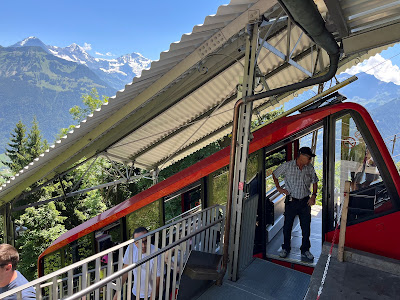
We got to stand directly next to the operator going up. I had to laugh at all of the buttons on the control panel. It reminded me of the instructions our host gave us about operating the oven (broil, convection, regular heat) and the dishwasher. It was helpful to have because we could not interpret the abbreviated German words on the controls. We had the same problem with our washing machine in Poland when we lived there. We just turned knobs until it started washing. I was glad the operator knew what he was doing.
I had never been on a funicular that actually turned a corner, just ones that went straight up the hill. This one made a 90 degree turn half way up the mountain. You can see how the wheel tracks for the cable are angled.
We went through a tunnel midway through. Our operator joked that this was the 'red light' district.
Here is the counterweighted car meeting us halfway.
The angle for the track was 65 degrees! Not quite straight up, but pretty close. The operator said the one with the greatest angle in the world is just up the valley. You get an idea from the shape of the car. The floor stayed level the whole time.
Eiger mountain (snow capped on the left), Jungfrau (center)
I've kept the live cam link on my phone for the top of Jungfrau. It thought it was funny to take a picture of the camera looking down the mountain at Interlaken while we were looking up at the mountain.
It was really obvious where we had hiked the previous day from Kleine Sheidegg to Wengen. There was a clear path visible where the Wengen Lauberhorn ski race (and our trail) went (marked in yellow)
You can see the entire town of Interlaken and Wilderswil. Up the canyon is Lauterbrunnen.
Lake Thun to the west.
Lake Brienzersee to the east. You can also see the airfield.
The paragliders simply step off this hillside and launch over the city. Watching them float above the lakes and city is totally mesmerizing. We counted no fewer than 20 when we walked to the train station the other day.
The yellow arrow is pointing to our airbnb. The West train station is in the lower right corner, with the Migros (grocery store) just above it (triangular building with part of a red roof). There is a school soccer field just next to our place and you can see the green next to the arrow.
The paragliders land in a large field in the center of town. You can see two of their shadows on the lawn to the left and a small yellow sail touching down to the right.
The top of the funicular.
Looking at Harder Kulm from the center of town.
This is the central green from the ground. The entire region is filled with beautiful gardens.
We named this the Ugly Hotel. Totally does not fit with the architectural beauty of the area. Just a giant block of concrete. ick.
Here is the school soccer field with a pick up game by neighborhood kids.
We were supposed to finish our day with a special Chocolate Making workshop at the Funky Chocolate Shop, but I messed up the reservation and we missed our time slot. I'm going to try to reschedule. We consoled ourselves with some apricot cake. Apparently apricots are very much a thing in this canton.


No comments:
Post a Comment